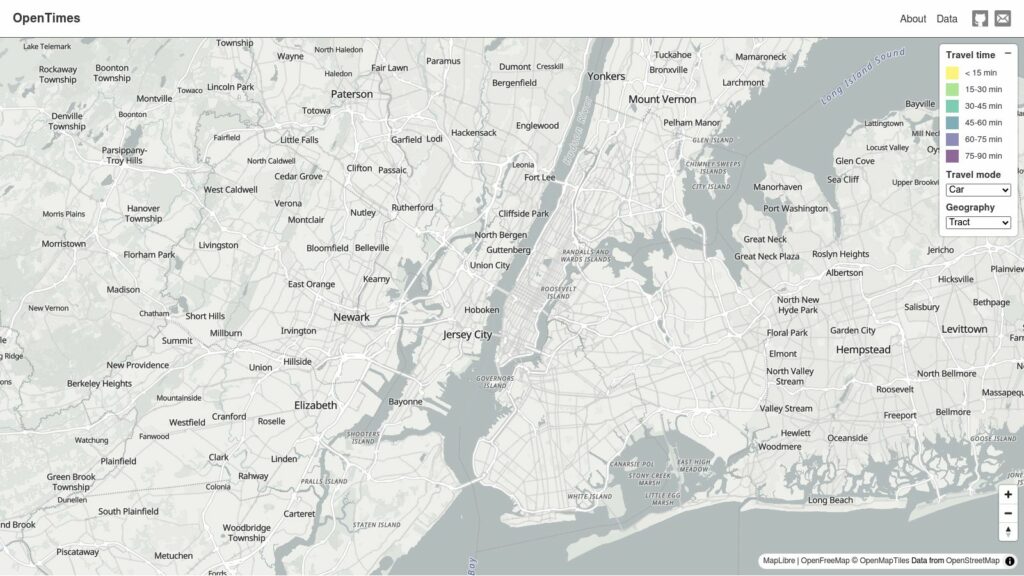
maps

OpenTimes

OpenTimes is an interactive travel-time map for the U.S., providing pre-computed, bulk-downloadable data on accessibility between Census geographies. It leverages open-source tools and public data for seamless integration into spatial analysis, enhancing mapping applications.

https://opentimes.org/

Air Tours

Air Tours is an interactive web app for exploring cities via Google Maps, featuring 3D, street view, and aerial perspectives. It enables seamless navigation and offers unique views and guided tours. Designed for desktop use, it includes AI-generated data, which may lack accuracy.

https://maps.tripgeo.com/airtours

Obscure Islands I Find Interesting

Interesting obscure islands:

  1. Pheasant Island – switches countries every 6 months.
  2. Ailsa Craig – granite supplier for curling stones.
  3. Tristan da Cunha – most remote inhabited island.
  4. Nikumaroro – possible Amelia Earhart death site.
  5. Hans Island – sparked Danish-Canadian conflict.
  6. Just Room Enough – smallest inhabited island.
  7. Palmyra Atoll – U.S. incorporated unorganized territory.
  8. Midway Atoll – acquired for bird guano.
  9. Sandy Island – fake on Google Maps.
  10. Devon Island – largest uninhabited island.
  11. North Sentinel – home to uncontacted tribe.
  12. Kiritimati – first to celebrate New Year's.
  13. Null Island – non-existent at 0°N 0°E.
  14. Wrangel Island – last woolly mammoth home.
  15. Diomede Islands – split by time zones.

https://amanvir.com/obscure-islands

Scroll to Top